What Is Geomorphology? Reading the Landscape Through Structure, Process and Time
Every field note on this blog asks the same question, even when it doesn't say so: why does this place look like this?
That question has a name — geomorphology, the study of landforms and the processes that shape them. It comes down to three things you can ask of any landscape: what is it made of, what's working on it now, and what timescales are layered into what you're seeing?
Structure. Process. Time. Ask all three, and scenery becomes a document.
Structure: the inherited script
Structure is the rock type, the way it formed, the fractures and boundaries written in long before erosion began — the hand the landscape was dealt.
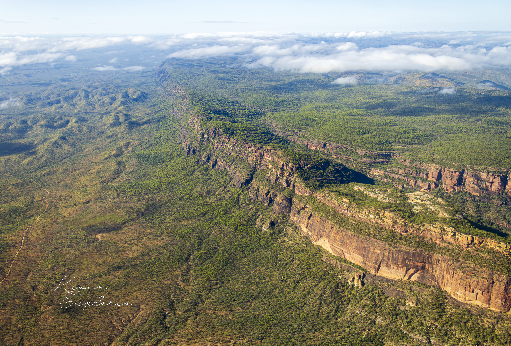
At Mt Mulligan (Ngarrabullgan), the sandstone capping the mountain was laid down ~270 million years ago in a rift basin — a block of country that dropped relative to its surroundings. The fault that set that basin's edge is still visible as a dead-straight 10km escarpment. Structure also explains vulnerability: the much older rock around Mt Mulligan, the Hodgkinson Formation, was pervasively fractured during an ancient mountain-building event — and that fracture network became the weak point 200 million years of weathering would exploit.
Process: the active agent
Process is what's currently shaping the structure — water, wind, weathering, gravity. Often too slow to see, sometimes visible in a single frame.
At Millstream Falls, a 1.24-million-year-old basalt flow buried the valley of the Millstream River, which spent that million years carving a new course — along the basalt-rhyolite boundary where it could, straight through the basalt where it couldn't. The falls themselves are process meeting structure directly: the river reaches the flat top of the lava flow, finds no weakness, and spreads sideways across the full width before plunging over.
Back at Mt Mulligan, process is the differential part of differential weathering: 200 million years of rain attacking the fractured Hodgkinson far more effectively than the intact sandstone above — same climate, same timespan, two different outcomes.
Time: the dimension that turns geology into a story
A landscape often holds multiple, unrelated timescales stacked on top of each other.
At Millstream Falls, the basalt is 1.24 million years old; the rhyolite beneath it is nearly 300 million years older again. And volcanism here continued into the Holocene — recently enough that Aboriginal oral history recorded by linguist R.M.W. Dixon describes what sounds like an eyewitness account of an eruption, later corroborated by pollen records showing the surrounding rainforest is less than 7,600 years old.
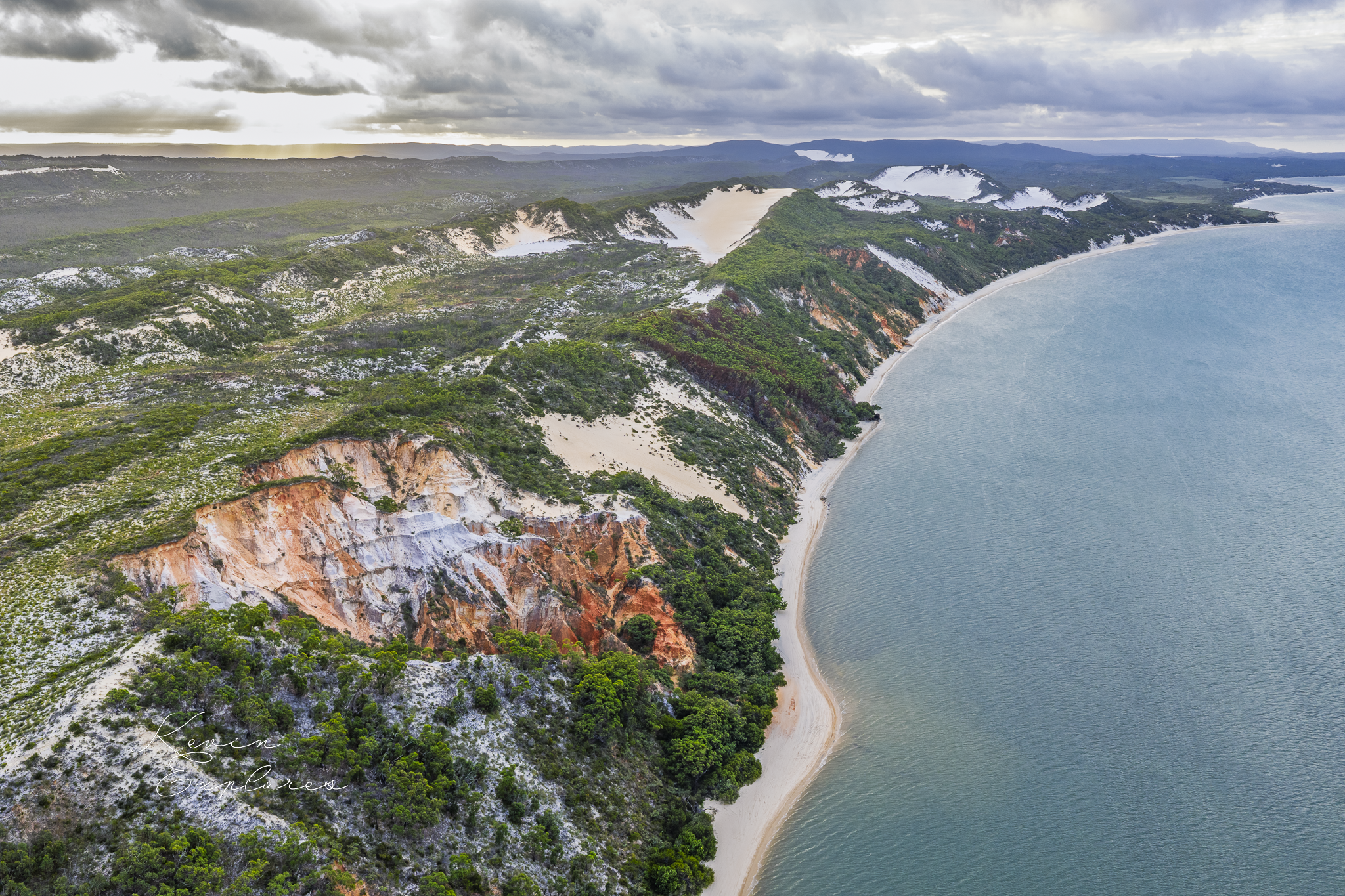
But time isn't always "deep" or finished. At Cape Bedford and Elim Beach, cliffs of sandstone and siltstone were laid down 95–170 million years ago, in shallow seas when Australia sat much further south than it does today. The dune system built on that ancient basement stabilised around 10,000 years ago — but hasn't stopped. The coloured sand bands — white quartz, orange-red iron oxides, dark heavy minerals — are stratigraphy in motion, still being reworked by wind and tide. Here, time is something you could photograph differently next year.


Why this matters from above
An aerial image is structure + process + time in a single frame — the shape of a ridge, the width of a waterfall, the colour of a dune. Asking the three questions doesn't complicate the landscape; it makes it legible. The landscape doesn't change. Your ability to read it does.
That's the project of this blog, post by post — the same country, better questions.
Further reading: "Where there is sandstone, there was a basin" (Mt Mulligan), "Millstream Falls — Rereading the Rock," and "Cape Bedford and Elim Beach: Where The Sea Meets Living Sands."