Bones Knob: a volcano hiding in plain sight
Kevin Explores · Atherton Tablelands Geology
Kevin Explores - Field Notes
Mar 14, 2026
Stand at the edge of the Atherton Tablelands and look north toward Mareeba, and you’ll see a broad, gentle hill rising modestly above the cane fields and macadamia orchards. Nothing about it shouts danger. Nothing suggests that the ground you’re looking at was, not so long ago in geological time, the source of one of the most significant lava flows in Far North Queensland. That hill is Bones Knob — and from the air it tells a geological story that rewards closer attention.
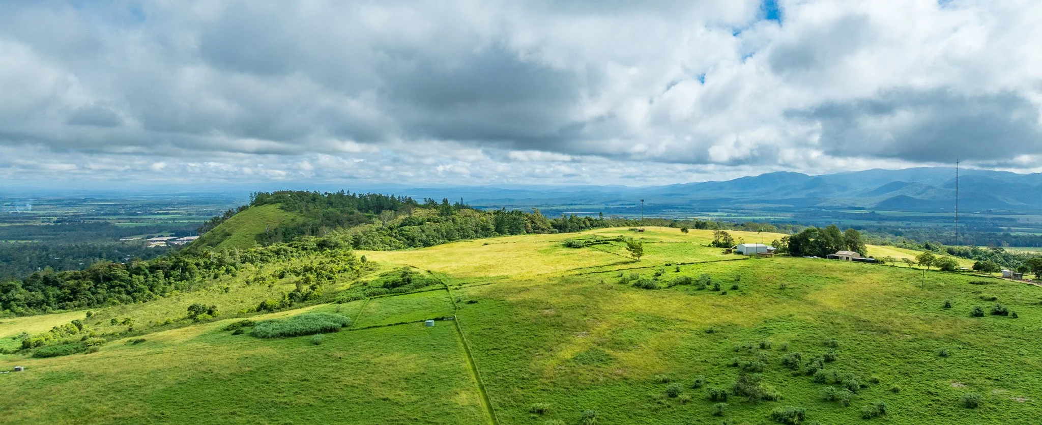
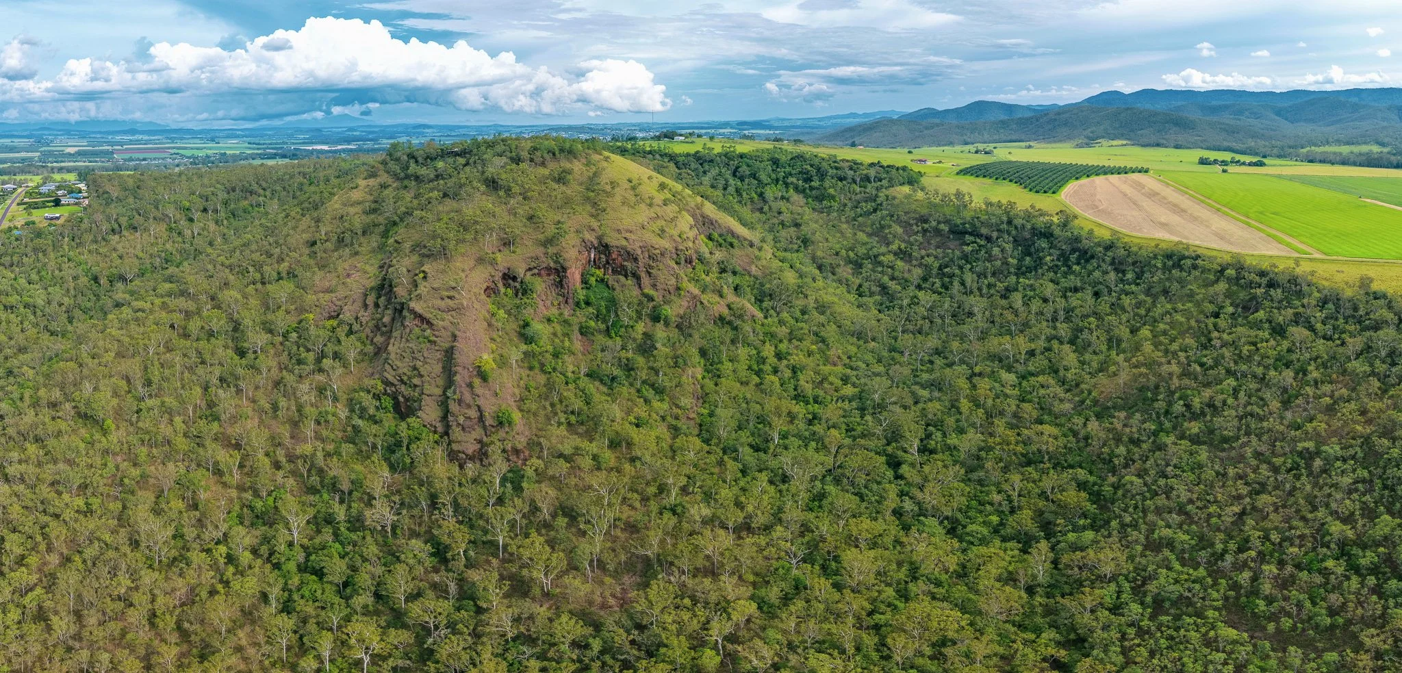
Image 1: Looking northeast from the south side of the Bones Knob shield volcano. The broad, gently rounded summit of the shield component occupies the left, its low-angle profile the signature of basalt that spread wide rather than building steep. The Barron Range and coastal ranges fill the horizon. The pastoral land in the foreground sits directly on shield flows that spread from this point nearly 1.8 million years ago.
The geological foundation
Bones Knob is documented in Whitehead et al. (2007) — the definitive study of the Atherton Basalt Province — as a two-stage volcanic system comprising a large shield volcano (Bones Knob 1, dated at 1.79 Ma) and a smaller parasitic scoria cone (Bones Knob 2, dated at 1.66 Ma) perched within a horseshoe-shaped depression on the shield’s northwestern flank.
The shield has a radius of approximately 2,800 m and rises 175 m above the surrounding country — one of the larger eruption centres in the province. The scoria cone is only 250 m in radius and 112 m high, but punches well above its weight in geological interest.
The basalts from the shield phase contain numerous prominent olivine phenocrysts — the magnesium-iron silicate mineral that crystallises early from cooling magma — and are readily distinguished from other flows in the province by this characteristic. Whitehead et al. note that these basalts flowed over 30 km to the north, beyond the present site of Mareeba. The lava that built the town’s soils and aquifers began its journey here.
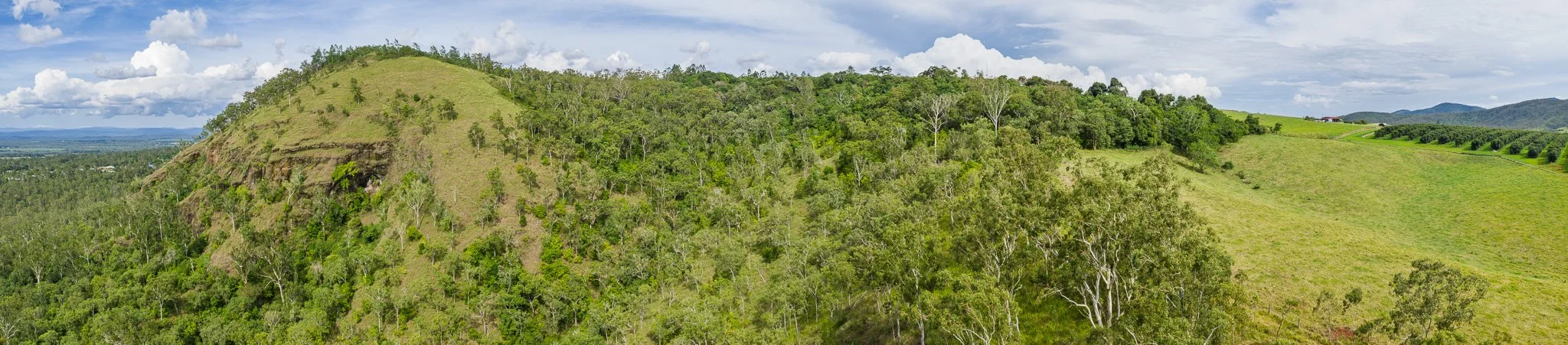
Image 2: Close panorama of the scoria cone’s northern face. The steep cone dominates the left, with a small cliff exposure marking the pyroclastic sequence beneath the grass. The forested horseshoe depression curves away to the right — the structural hollow that records either an explosive maar-phase eruption or preferential erosion of the friable scoria. Farm buildings visible on the far right.
Reading the landscape from above
The drone imagery reveals the geomorphological story with unusual clarity. Two features in particular are immediately diagnostic.
The horseshoe depression
The curved embayment into the northwestern side of the main cone is the most striking landform feature. Whitehead et al. interpret this as either the product of an initial maar-style eruption that excavated a crater at least 500 m across — before subsequent pyroclastic deposits built the scoria cone — or as the result of preferential erosion of the friable scoriaceous deposits after the shield flows surrounded the cone. Either interpretation is geologically significant: the horseshoe geometry is not random erosion but the preserved imprint of the eruptive sequence itself.
The columnar jointing
The cliff faces visible in the drone images expose what Whitehead et al. describe as poorly developed columnar jointing in the pyroclastic deposits, with columns nearly 1 m across. Columnar jointing in pyroclastic material requires deposition in a sufficiently hot and massive state to partially weld the fragments before cooling and contraction produce the vertical fractures. Such structures are unusual in basaltic pyroclastic deposits anywhere, and those at Bones Knob are noted as unique within the entire Atherton Basalt Province.
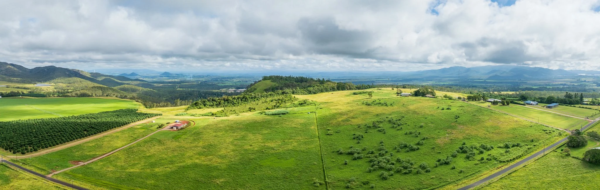
Image 3: Wide panorama with the scoria cone sitting in mid-distance, showing its relationship to the surrounding agricultural landscape — orchards left, fields right, the Great Escarpment and Wet Tropics ranges across the horizon. The fertile red soils across this entire view began as Bones Knob basalt, weathered over nearly two million years.
The living landscape
The vegetation patterns visible in the imagery are themselves a direct expression of volcanic geology. The exposed pyroclastic cliffs support sparse, stress-tolerant communities adapted to skeletal soils. The lower slopes, where weathered basalt has developed into the deep krasnozem soils characteristic of the Tablelands, carry subtropical dry sclerophyll forest. The cleared summit demonstrates the extraordinary agricultural productivity of these basaltic soils — the same olivine-bearing basalt that makes Bones Knob geologically interesting also weathers to produce the most fertile soil types in Far North Queensland.
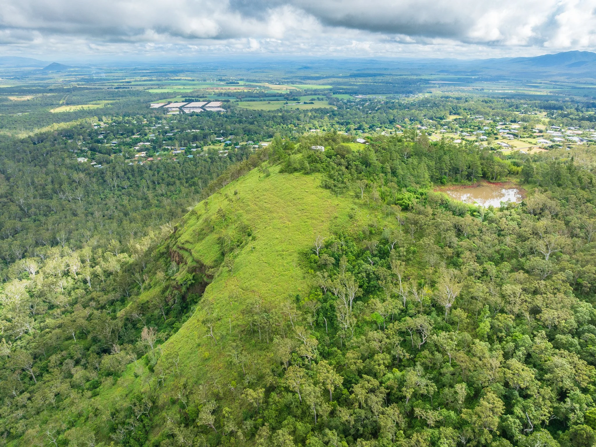
Image 4: Looking straight down onto the top of the scoria cone, its grassed summit ridge running diagonally across the frame. Tolga township spreads across the background, a farm dam visible top right. The town sits on basalt flows that erupted from this point 1.79 million years ago — the agricultural landscape entirely dependent on what lies beneath.
The eruptive sequence
The 130,000-year gap between the two dated events at Bones Knob raises important questions about the subsurface history. Whitehead et al. offer two alternative interpretations of the relationship between the eruption centres.
In the first interpretation, a maar-style eruption — phreatomagmatic, involving water-magma interaction at depth — excavated a large crater into the shield’s northwestern flank after the shield was already built. This crater then became the site of the subsequent pyroclastic activity that built the scoria cone. A deep, explosive eruption penetrated and disrupted the existing volcanic edifice.
In the second, the scoria cone predates the shield, and the horseshoe depression marks preferential erosion of the pyroclastic deposits after the surrounding shield flows buried the cone’s base. The age data marginally favour the first scenario, but the difference in dates is within experimental uncertainty.
What is not in doubt is the welded columnar jointing. The Bones Knob scoria cone preserves evidence for an unusually energetic eruptive phase — temperatures more typical of large silicic welded ignimbrites than of small basaltic cinder cones. Whatever the precise sequence, this eruption was outside the normal range for the province.

Image 5: The scoria cone’s cliff face seen head-on — the most complete exposure of the pyroclastic sequence at Bones Knob. The reddish-brown oxidised scoria tells the eruption story directly: iron reacting with oxygen as molten cinders tumbled through the atmosphere before landing. Red scoria means a hot, gas-charged eruption.

Image 6: Close approach to the cliff face reveals the layered pyroclastic sequence in detail. The horizontal banding records successive depositional phases of the eruption. The cave-like recess at centre may mark the welded zone — where deposits landed hot enough to partially fuse, producing the columnar jointing documented as unique in the Atherton Basalt Province.
What Bones Knob tells us about the province
In the broader context of the Atherton Basalt Province’s evolution, Bones Knob sits at a transitional moment. The 1.79–1.66 Ma period falls within the province’s second major episode of shield-building activity — just before the shift toward smaller cinder cone eruptions that characterised the last million years. Bones Knob represents the tail end of the era of voluminous, effusive eruptions, while its parasitic scoria cone signals the more explosive, gas-rich magmatic character that would come to define the younger volcanic centres.
The province as a whole tells a story of waning magmatic supply: from valley-filling shield volcanoes drawing on deep, partially molten mantle material, to the smaller and more volatile-rich eruptions of the maar and cinder cone phase. Bones Knob sits at that inflection point. It is simultaneously one of the last great shield systems and the site of one of the more unusual pyroclastic events in the province’s record.
From above with a Mavic 4 Pro, all of this is legible. The broad, gentle shield profile. The horseshoe depression. The exposed cliff face. The olivine-bearing basalt soils feeding the orchards below. The geology is not buried here — it is the landscape.
Geological data: Whitehead, P.W., Stephenson, P.J., McDougall, I., Hopkins, M.S., Graham, A.W., Collerson, K.D. and Johnson, D.P. (2007). Temporal development of the Atherton Basalt Province, north Queensland. Australian Journal of Earth Sciences 54:5, 691–709.
All aerial photography: Kevin Explores / Mavic 4 Pro, January 2026.