Millstream Falls - Rereading the Rock
Millstream Falls National Park
Millstream Falls isn't new to me. I've shot it before — drone footage, stills, the usual passes. I thought I had it.
Then I went back to the literature.
Specifically, to the work of JCU and ANU geologists who dated the basalt flows here to 1.24 million years, and to Warwick Willmott's careful reading of what those flows actually mean for the landscape you can see. I went back to the falls this morning with that knowledge in my head and a different set of questions. Same place. Completely different shoot.
That's the thing about geological interpretation. The landscape doesn't change. Your ability to read it does. And once you start reading it, the familiar becomes extraordinary.
Here's what the rock is saying.
The hill you can see from Ravenshoe — the broad, gently sloping ridge now occupied by the wind farm east of town — is Windy Hill volcano. It doesn't look like a volcano because it isn't one anymore. The summit has collapsed. What remains is the eroded flanks of a shield volcano that geologists from James Cook University and the Australian National University dated, from samples collected right here at Millstream Falls, at 1.24 million years old. Two samples. Widely separated locations. Same answer. That's not an estimate — that's a date stamped into the rock by physics.
From Windy Hill, lava poured more than 25 kilometres south and southwest, filling an old valley of the Millstream River. The river, suddenly entombed, had to find a new way. It worked along the margins between the fresh black basalt and the older surrounding rocks — rhyolite, in this case, from a completely different volcanic episode nearly 300 million years older. Where the boundary was exploitable, the river followed it. Where it wasn't, the river cut directly into the basalt itself. That patient negotiation between water and rock over a million years is what produced this gorge.
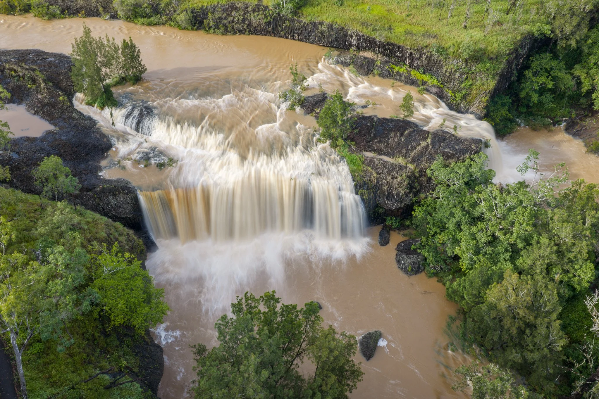
The falls are a direct expression of the lava's geometry.
The basalt flows cooled from the outside in. As they solidified, they contracted — and that contraction drove fractures downward through the rock in a repeating pattern. Hexagonal columns, mostly, though rectangles and irregular polygons appear too. The physics is the same as a beehive, the same as dried mud. The result here is those columns in the lower cliff faces — a permanent record of how the rock was made, written into the gorge wall at full scale.
The upper surfaces of these flows stayed horizontal — flat, level, essentially as the lava left them. That geometry is why the falls are so wide. The river reaches that shelf, finds no weakness to exploit, and spreads sideways across the full width before going over the edge all at once. The shape of the waterfall is the shape of the lava flow.
Geologist Warwick Willmott put the connection plainly: the falls plunge in a wide curtain over the horizontal lowermost lava flow, showing how geology can directly shape the appearance of streams and falls. It's not poetry. It's mechanics. But the result is extraordinary.
The long exposure in this set shows what I mean — the silked water breaking over the column tops, geology and hydrology in a single frame.
The literature tells me that from sufficient altitude the boundary between the basalt and the rhyolite is readable as two distinct vegetation types — denser forest on the dark soils, open eucalypt woodland on the pale — but that's a story for another shoot, with better positioning and the right season.
This volcanic landscape was also witnessed.
The Atherton Basalt Province didn't finish its activity before people arrived. Research published in the Australian Journal of Earth Sciences confirms that volcanic eruptions in this region continued well into the Holocene — within the last 10,000 years, and possibly much more recently. The crater lakes you can visit today — Barrine, Eacham, Euramoo — formed within human memory. Aboriginal oral history recorded by linguist R.M.W. Dixon in 1972 includes a detailed account of the formation of those lakes that Dixon described as a plausible description of a volcanic eruption. The storyteller noted that the country around the lakes was open scrub at the time — a detail later confirmed by pollen analysis, which showed the present rainforest to be less than 7,600 years old. People watched this landscape being made. Their knowledge of it is older than the forest that now surrounds it.
The Google Earth image in this set shows the spatial relationship — Windy Hill to the east of Ravenshoe, the flow path running south and southwest, Millstream Falls sitting at the end of the line. Twenty-five kilometres from source to falls, written in rock.
If you want to understand this country — really understand it — start with the rock. Everything else follows.
If you are interested in information like this, please follow me or subscribe kevinexplores.substack.com
Cheers, Kevin
Millstream Falls National Park · Ravenshoe · Atherton Tablelands
Kennedy Highway, 3km west of Ravenshoe
Aerial footage: Mavic 4 Pro
Geological sources: Willmott, W.F. — Rocks and Landscapes of the National Parks of North Queensland, Geoscience Australia; Whitehead et al. (2007) — Temporal development of the Atherton Basalt Province, Australian Journal of Earth Sciences 54:5.